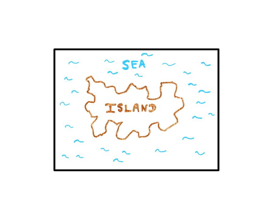
Say that you are tasked with figuring out how to measure a coastline (i.e., the length). To do this, you are given a very detailed map of an arbitrary island. It sounds like a relatively simple task, right? Well, the catch is that you will have to get as accurate a measurement as possible. Whenever we talk about accurate measurements, science is involved.
In this article, I will guide you through the process of how we could try to solve this problem. Along the way, you will realise that hidden behind this problem is a strange, yet profound phenomenon. Understanding this phenomenon would give you a broader perspective of areas in science that we hardly understand as human beings. Let’s get started.
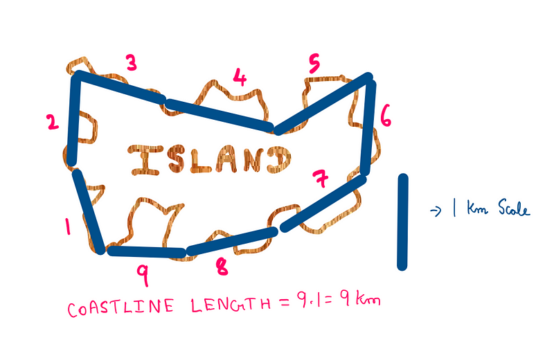
Let’s say that we have a scale that is 1 Kilometre (Km) long. We can now use this scale to measure the length of the island’s coastline. We can be certain that it is not the most accurate way. But this will enable us to understand how to proceed.
Illustration created by the author (ironically, not drawn to scale)
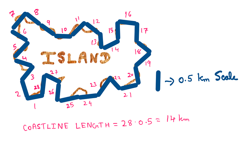
It appears that using our 1 Km scale, we managed to measure that the island’s coastline is 9 Km long. Of course, with the 1 Km scale, we did not manage to capture the bends, twists, nooks, and crannies. So, how do we capture these details using a scale? How about if we use a smaller scale? Right, let’s use a 0.5 Km scale (half the size of our original scale) and see what results we get.
Illustration created by the author (ironically, not drawn to scale)
This is an interesting result. Using a scale that is 0.5 Km long, the coastline length has increased from 9 Km to 14 Km. The basic idea we get out of this is the following:
While measuring irregular/jagged coastlines, whenever we increase our measurement’s resolution (i.e., reduce the scale’s size), the coastline length only increases.
This happens because, as we refine our resolution, the number of bends and twists that we capture only increases.
What is the Right Scale?
So far, we have established that reducing the size of the scale is the right way to proceed. This way, we are guaranteed to get the most accurate measurement at some point. The next question is: what is the right size for the scale?
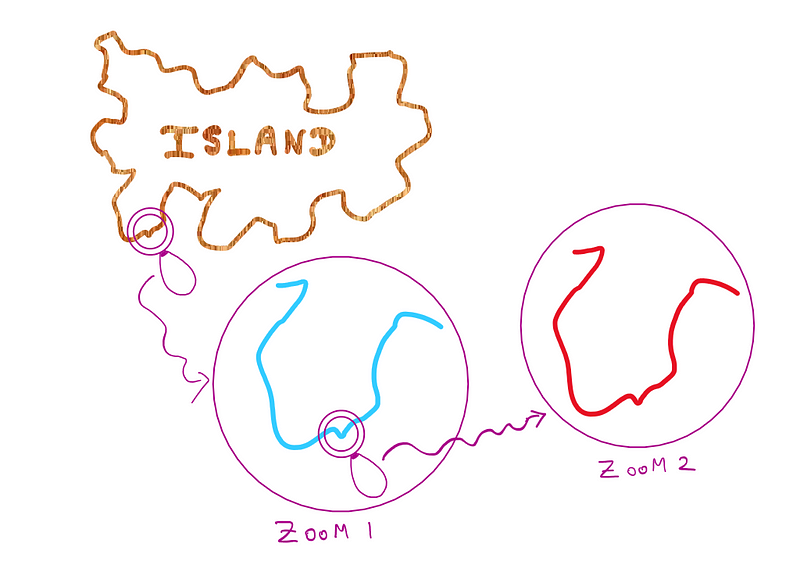
We first need to zoom into the details of the island’s coastline. Then, we need to figure out what the size of the smallest bend or twist in the coastline is. Once we figure this out, we could use a scale that is sufficiently small enough to measure this bend or twist. If this scale can measure the smallest bend or twist, it can be successfully employed to measure the entire coastline accurately.
We have a plan! So far, so good. Let’s go ahead and zoom into the island’s coastline.
Illustration created by the author (ironically, not drawn to scale)
The first time we zoom into the little blip in the southwestern section of the island, we come across something strange. The zoomed-in section looks largely like the bigger section that it belongs to. Okay, this is strange, but strange things happen, right?
It just happens to be the case that this section also has a smaller micro blip. The second time around, we zoom into this smaller micro blip. Surprise, Surprise! This zoomed image reveals a section that also looks like the other two parent sections it is a part of. Surely, I must be pranking you, right? Just what is going on here?
Fractality
Unfortunately, I’m not pranking you here. It turns out that coastlines have a special property. No matter how much we zoom in, they seem to largely feature structures that resemble the parent structures.
We typically think that if we keep zooming in, the features of the coastline would straighten out at some point. But contrary to this intuition, coastlines never straighten out regardless of the zoom level. They seem to feature smaller and smaller bends and twists that resemble the bigger bends and twists (down to the microscopic level, and beyond).
To help you understand this, imagine a tree whose branch resembles the whole tree. Now, a sub-branch within this branch resembles the branch that resembles the whole tree, and so on. Another example: Imagine a picture in which you are smiling. Someone zooms into your eyes in the picture and surprisingly finds a copy of the entire original picture (with you smiling, of course!). They now zoom into the eyes of your picture that they found in the eyes in the original picture, only to experience the same loop again. This loop keeps going on without any sign of stopping.
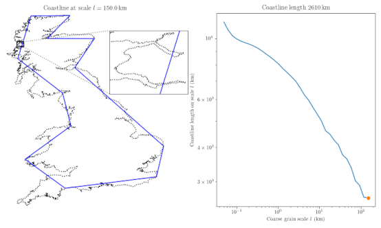
In a rough sense, this phenomenon is known in mathematics as fractality. You might be sceptical about my arbitrarily drawn island. But here is an animation of researchers trying to measure the coastline of Great Britain.
You can see that the coastline length keeps on increasing as the measurement’s resolution is increased.
The Paradox
In the end, it turns out to be the case that it is impossible to measure coastlines accurately. Because of their fractal nature, coastlines seem to have an infinite length as we keep zooming in. This phenomenon was originally recorded by Lewis Fry Richardson. Later on, self-appointed “fractalist” Benoit Mandelbrot (one of my all-time heroes) contributed significantly to the research on this phenomenon and several related phenomena.
As for the coastline length measurement, as long as we agree to arbitrarily fix the scale to a particular size, we can measure a meaningful number. But keep in mind that all other coastlines have to be measured using the same scale. Otherwise, the numbers we get out of different scales would be meaningless and misleading when compared. Due to their fractal nature, coastlines produce different numbers at different scales.
To conclude, it is a bit of an anti-climax, but it really is impossible to measure coastline lengths accurately. And this phenomenon is not just limited to coastlines.
Fractality seems to occur all over nature: from plant leaves and fingerprints to planets and galaxies. It is nature’s expression of randomness that still stumps the best brains we have as human beings. Perhaps, certain phenomena are simply not meant to be fully understood by human beings after all!
I hope you found this article interesting and useful. If you’d like to get notified when interesting content gets published here, consider subscribing.
We use cookies on our website to give you the most relevant experience by remembering your preferences and repeat visits. By clicking “Accept”, you consent to the use of ALL the cookies.
This website uses cookies to improve your experience while you navigate through the website. Out of these, the cookies that are categorized as necessary are stored on your browser as they are essential for the working of basic functionalities of the website. We also use third-party cookies that help us analyze and understand how you use this website. These cookies will be stored in your browser only with your consent. You also have the option to opt-out of these cookies. But opting out of some of these cookies may affect your browsing experience.
Necessary cookies are absolutely essential for the website to function properly. These cookies ensure basic functionalities and security features of the website, anonymously.
Cookie
Duration
Description
cookielawinfo-checkbox-advertisement
1 year
Set by the GDPR Cookie Consent plugin, this cookie is used to record the user consent for the cookies in the "Advertisement" category .
cookielawinfo-checkbox-analytics
11 months
This cookie is set by GDPR Cookie Consent plugin. The cookie is used to store the user consent for the cookies in the category "Analytics".
cookielawinfo-checkbox-functional
11 months
The cookie is set by GDPR cookie consent to record the user consent for the cookies in the category "Functional".
cookielawinfo-checkbox-necessary
11 months
This cookie is set by GDPR Cookie Consent plugin. The cookies is used to store the user consent for the cookies in the category "Necessary".
cookielawinfo-checkbox-others
11 months
This cookie is set by GDPR Cookie Consent plugin. The cookie is used to store the user consent for the cookies in the category "Other.
cookielawinfo-checkbox-performance
11 months
This cookie is set by GDPR Cookie Consent plugin. The cookie is used to store the user consent for the cookies in the category "Performance".
CookieLawInfoConsent
1 year
Records the default button state of the corresponding category & the status of CCPA. It works only in coordination with the primary cookie.
viewed_cookie_policy
11 months
The cookie is set by the GDPR Cookie Consent plugin and is used to store whether or not user has consented to the use of cookies. It does not store any personal data.
Functional cookies help to perform certain functionalities like sharing the content of the website on social media platforms, collect feedbacks, and other third-party features.
Performance cookies are used to understand and analyze the key performance indexes of the website which helps in delivering a better user experience for the visitors.
Cookie
Duration
Description
_gat
1 minute
This cookie is installed by Google Universal Analytics to restrain request rate and thus limit the collection of data on high traffic sites.
Analytical cookies are used to understand how visitors interact with the website. These cookies help provide information on metrics the number of visitors, bounce rate, traffic source, etc.
Cookie
Duration
Description
__gads
1 year 24 days
The __gads cookie, set by Google, is stored under DoubleClick domain and tracks the number of times users see an advert, measures the success of the campaign and calculates its revenue. This cookie can only be read from the domain they are set on and will not track any data while browsing through other sites.
_ga
2 years
The _ga cookie, installed by Google Analytics, calculates visitor, session and campaign data and also keeps track of site usage for the site's analytics report. The cookie stores information anonymously and assigns a randomly generated number to recognize unique visitors.
_ga_R5WSNS3HKS
2 years
This cookie is installed by Google Analytics.
_gat_gtag_UA_131795354_1
1 minute
Set by Google to distinguish users.
_gid
1 day
Installed by Google Analytics, _gid cookie stores information on how visitors use a website, while also creating an analytics report of the website's performance. Some of the data that are collected include the number of visitors, their source, and the pages they visit anonymously.
CONSENT
2 years
YouTube sets this cookie via embedded youtube-videos and registers anonymous statistical data.
Advertisement cookies are used to provide visitors with relevant ads and marketing campaigns. These cookies track visitors across websites and collect information to provide customized ads.
Cookie
Duration
Description
IDE
1 year 24 days
Google DoubleClick IDE cookies are used to store information about how the user uses the website to present them with relevant ads and according to the user profile.
test_cookie
15 minutes
The test_cookie is set by doubleclick.net and is used to determine if the user's browser supports cookies.
VISITOR_INFO1_LIVE
5 months 27 days
A cookie set by YouTube to measure bandwidth that determines whether the user gets the new or old player interface.
YSC
session
YSC cookie is set by Youtube and is used to track the views of embedded videos on Youtube pages.
yt-remote-connected-devices
never
YouTube sets this cookie to store the video preferences of the user using embedded YouTube video.
yt-remote-device-id
never
YouTube sets this cookie to store the video preferences of the user using embedded YouTube video.

Comments